Winter Storm Warning
Dave Epstein says:
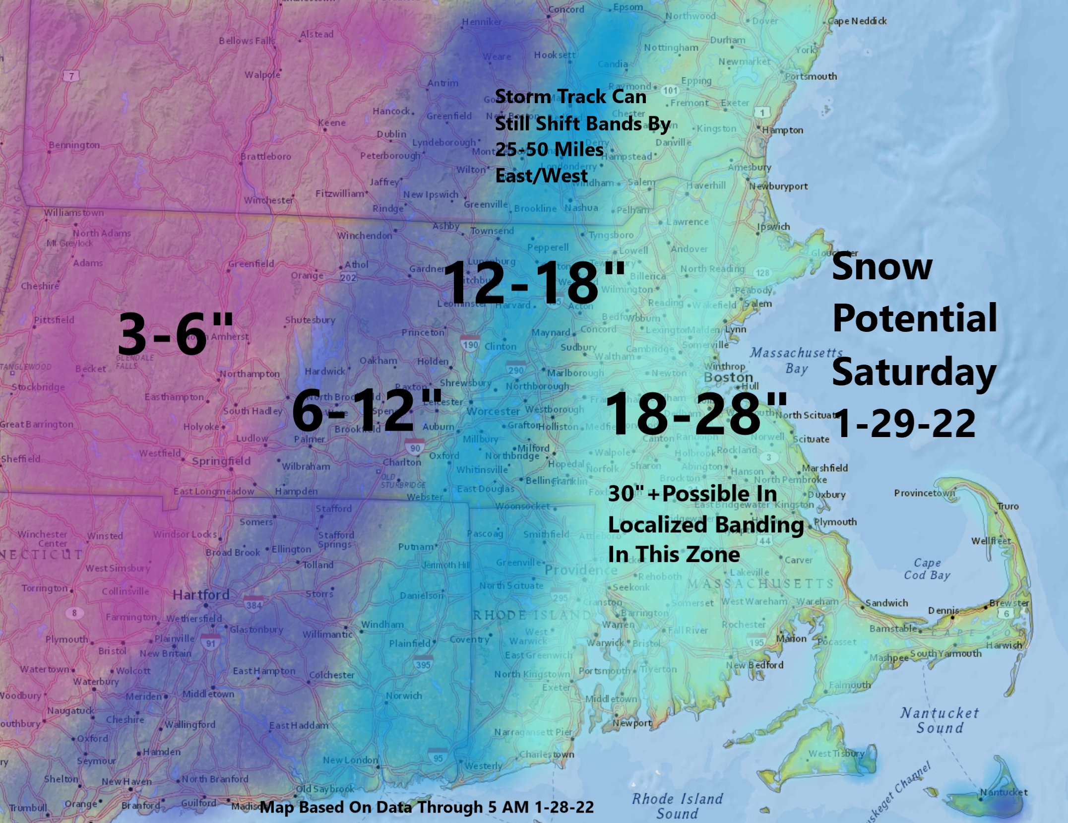
“This is perhaps the highest snowfall potential totals map I have ever made. Banding most likely over southeastern MA, but could occur anywhere in the highest zone. Most of this falls from 7 am to 7pm Saturday, final flakes around midnight. #WeatherWisdom“
National Weather Service Warning:

URGENT - WINTER WEATHER MESSAGE
National Weather Service Boston/Norton MA
335 AM EST Fri Jan 28 2022

MAZ005-006-013-014-RIZ001>008-282145-
/O.UPG.KBOX.WS.A.0005.220129T0500Z-220130T0500Z/
/O.NEW.KBOX.WS.W.0004.220129T0500Z-220130T0500Z/
Central Middlesex MA-Western Essex MA-Western Norfolk MA-
Southeast Middlesex MA-Northwest Providence RI-
Southeast Providence RI-Western Kent RI-Eastern Kent RI-
Bristol RI-Washington RI-Newport RI-Block Island RI-
Including the cities of Framingham, Lowell, Lawrence, Foxborough,
Norwood, Cambridge, Foster, Smithfield, Providence, Coventry,
West Greenwich, East Greenwich, Warwick, West Warwick, Bristol,
Narragansett, Westerly, Newport, and New Shoreham
335 AM EST Fri Jan 28 2022

...WINTER STORM WARNING IN EFFECT FROM MIDNIGHT TONIGHT TO
MIDNIGHT EST SATURDAY NIGHT...

* WHAT...Heavy snow expected. Total snow accumulations of 15 to
  19 inches. Winds gusting as high as 60 mph.

* WHERE...Portions of eastern and northeastern Massachusetts and
  northern and southern Rhode Island.

* WHEN...From midnight tonight to midnight EST Saturday night.

* IMPACTS...Travel could be very difficult to impossible. Strong
  winds could cause tree damage.

* ADDITIONAL DETAILS...snowfall rates of 2 to 4 inches per hour is
  possible at times.

PRECAUTIONARY/PREPAREDNESS ACTIONS...

If you must travel, keep an extra flashlight, food, and water in
your vehicle in case of an emergency.

&&

$$